So out on the road again, this time over to Boyle in County Roscommon. This is listed has number 23 on the rally map, link Here .
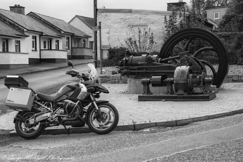
While getting this photo I met a local lady, No name given but was told a little of the history behind the steam driven motor and the generator sitting to the front. She lived outside the town when a child. She is 80 years young and bright has a spark. Her father use to take her and her sister up onto a hill top close to her home to see the northern lights. It was only when she got older that realized what her father was showing them was the electric lights in the town of Boyle. It’s a Blackstone engine and helped generate electricity for Boyle until 1965 with DC power. After our chat I did offer to take her a spin around the town on the bike, with a wink of her eye and telling me if she was ten years younger we parted with a laugh and a smile on my face. A wonderful women.
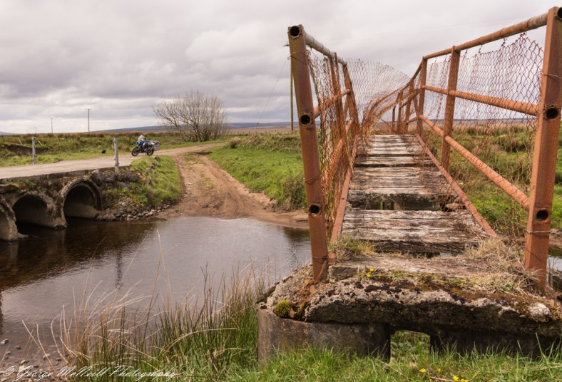
My next trip out was to County Mayo over on the west coast, this time to a remote, or has we would say ” in the asshole of nowhere” to find a disused footbridge. The ride out to it was all single track roads, passing a remote house out here you wonder what it must be like in winter since its flat scrub land and the wind was racing across it. When I got to the bridge the road ends and a private lane continues up to a farm about a half mile away. The river it crosses has brown water due to it running through the peat bog’s, and here’s a tip don’t drink the water.
It turned out to be a long day in the saddle and the rain held off for most of the day.
My next ride out was up to the northern part of County Donegal, Glenveagh National Park area. The day was great with blue sky’s from early morning it promised to be a warm day. Going direct from home to the rally point was around 3.5 hours but I’m not known for going the direct route. The plan was to travel through Counties Monaghan, Cavan, Fermanagh and into Donegal. Up the shore of lower Lough Erne in Country Fermanagh to Kesh.

This was taken from a view point just outside Kesh town in County Fermanagh, this is looking north up Lower lough Erne.
Then onto the small town of Pettigo which is in part of Northern Ireland (UK) and part in Donegal (ROI). Through Donegal town and a drive up the centre of the county to Church hill. Then follow the R251 (road)around the north of Glenveagh National Park and down to lough Dunlewy.

This is looking down from the road on the side of Mount Errigal, Donegals highest mountain. The lough in Lough Dunlewy and the area with the church ruins in the bottom left is the Poisoned Glen. The history of the glen is linked with the photo rally point which is just out of shot in the top right of this photo. Here’s a link to the Poisoned Glen.
The church ruins in the Poisoned Glen was a photo rally point a few years back.
Next the Rally Point, this is number 1 on the map. It’s called Lugh Lambfada and another link. Lugh

Not a great time of day for photography with high contrast but sometimes you have to make do. This is Lugh and here is the pilot of the bike to give scale to the sculpture

Complete with body armour in case I had to fight him. I done another rally point in Northern Ireland on the return trip but well leave that from another post
Thank you all for visiting and be safe wherever you are.

You must be logged in to post a comment.